Kedron Brook Bikeway
One of Brisbane North's most popular bikeway, the Kedron Brook is a great place to get the family out for a ride in the sunshine!
User Rating

![]() (45 reviews)
(45 reviews)


User Rating
![]() (4 reviews)
(4 reviews)
This is another ride that can be ridden from public transport – with the route starting from Ferny Grove station. Of course, you could join onto the Kedron Brook cycleway quite easily as well if you wanted to ride out from Northern Brisbane.
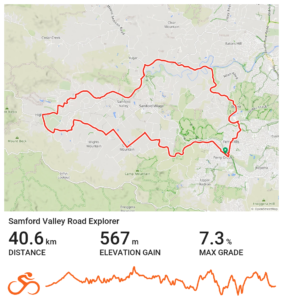
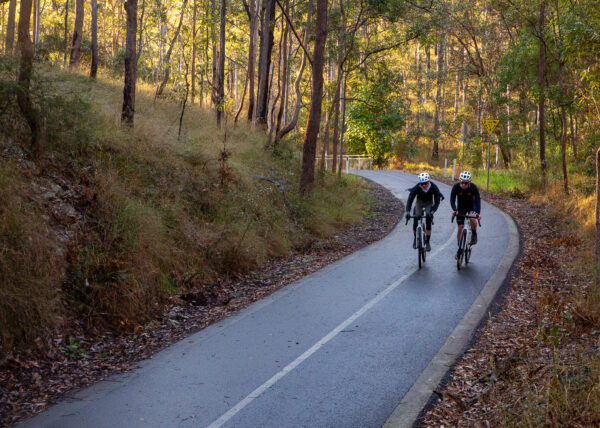
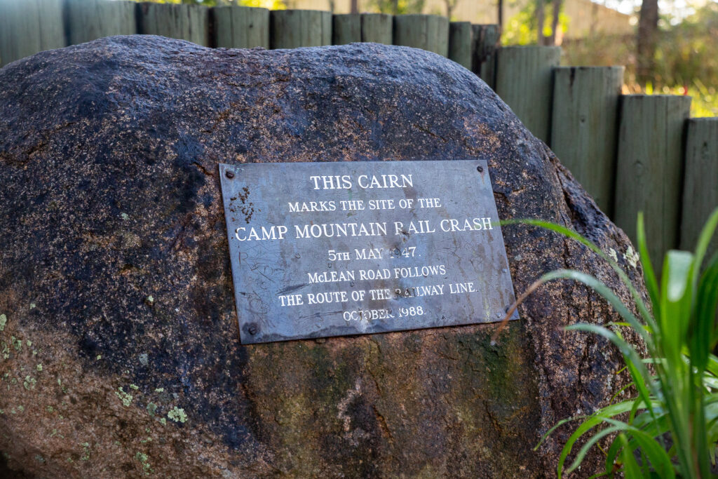
Heading west from Ferny Grove station, this route follows the old rail line and the Samford Cycle Link. The Cycle Link is sealed through the rail trail into the Samford Valley – and once onto McLean Road South on the other side, you also pass the Camp Mountain Rail Disaster memorial – this is still Queensland’s biggest rail tragedy, where the train ran off the tracks in May 1947.

At the T intersection, turn left into Camp Mountain Road. This slight rise tends to a slight descent before a 90 degree left into Upper Camp Mountain Road. Some of the properties on your left are larger and mostly unsubdivided – there is also an ecological research facility on your right!
This road is undulating until a right hand turn onto Richards Road, and a dog leg to Westbourne Avenue. This is a wide road with plenty of room for riders as it travels from Wights Mountain to Highvale. While there are many other roads to turn into, most of these are dead ends – but if you have a gravel bike, many do connect on a network of trails.
At the next intersection turn left into Moonlight Avenue. Follow the route and keep an eye out for a pass through on the right. There are some horse step overs you may need to navigate – but this side quest keeps you off the main road! Onto the base of Kareela Avenue, climb upwards, turn left onto Hulcombe Road and follow it to Ryder Road, and the causeway over Dawson Creek.
At the end, turn right onto Samford-Mt Glorious Road and then left into Showgrounds Drive. Turn right into Westwood Drive and follow this local road through to Mt O’Reilly Road, and then left onto Gibbons Road. Having traced the southern and western edge of Samford Valley you are now on the (extended) return leg.
Gibbons Road does get narrower but it is only a 60km/h road – at the end turn left into the bike lane on Samford-Dayboro Road. This has been widened as part of a major refurbishment along Eatons Crossing Road, which you need to cross traffic on the uphill to turn right on. Due caution is required.
Follow the bike lane then turn right onto Bunya Road for a fun descent to cross the South Pine River. Stay on this road until you turn right on Woodhill Road and right again onto Tarnook Drive. Follow the route back to Ferny Grove station – or onto your next ride if you are joining on to the Kedron Brook Cycleway or another ride.

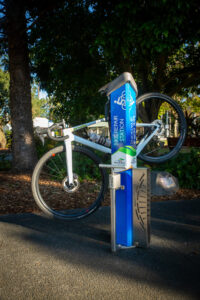
If you divert into Samford Village, there are a myriad of cafes – but also some handy bike tools, work stand and pump right at John Scott Park.
One of Brisbane North's most popular bikeway, the Kedron Brook is a great place to get the family out for a ride in the sunshine!
User Rating
![]() (45 reviews)
(45 reviews)
Just 30 minutes from the Brisbane CBD you can find the Ferny Grove Rail Trail leading out to the "country" town of Samford Valley.
User Rating

![]()
![]() (39 reviews)
(39 reviews)
An iconic ride for Brisbane bike riders. Do it on your gravel bike or mountain bike for the maximum fun.
User Rating
![]()
![]() (46 reviews)
(46 reviews)
There are nearly endless different rides we can do. Rides that take us to new places, unique vistas and places of interest. T...
User Rating
![]() (18 reviews)
(18 reviews)